Page 1 of 1
[Solved] Set GPS from Centre of GC’s Own Map
Posted: Fri Sep 21, 2018 6:52 pm
by Facherty
When a photo lacks a GPS value, it would be very convenient to:
- scroll around GraphicConverter's own map
- find an acceptable place
- use a command in the GPS menu that reads, "Set GPS from GC Map".
At the moment, this requires launching Google Earth and doing similar activities...
Re: Set GPS from Centre of GC’s Own Map
Posted: Sat Sep 22, 2018 8:54 am
by forum_adm
In the browser:
Just click hand hold around two seconds into the map and the location will be set as GPS value.
Re: Set GPS from Centre of GC’s Own Map
Posted: Mon Oct 01, 2018 12:31 pm
by Facherty
Thorsten
Many thanks - I did not know that one, and it is a very helpful feature.
Possibly worth adding as a menu item?
Best wishes,
Andrew
Re: Set GPS from Centre of GC’s Own Map
Posted: Mon Oct 01, 2018 4:48 pm
by forum_adm
Andrew,
how should the menu item work?
Thorsten
Re: Set GPS from Centre of GC’s Own Map
Posted: Mon Oct 01, 2018 7:09 pm
by Facherty
Like this:
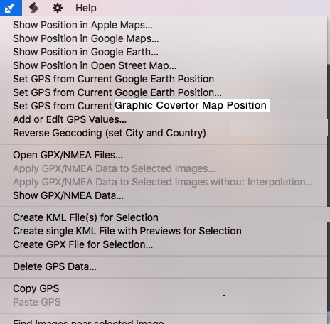
- GC GPS Menu.jpg (73.09 KiB) Viewed 7452 times
?
Re: Set GPS from Centre of GC’s Own Map
Posted: Thu Oct 04, 2018 11:04 pm
by macvf
OK, but after selecting this option a dialog should be displayed telling the user to click in the Map at the right position, otherwise GC will not know which position to select as there is no cursor on the Map.
Re: Set GPS from Centre of GC’s Own Map
Posted: Thu Oct 04, 2018 11:10 pm
by Facherty
I’m not sure why that dialogue would be necessary. It certainly isn’t necessary when Google Earth is used for exactly the same task.
A check is already built into the Google Earth process: it asks, "Are you sure you want to overwrite the current GPS settings?"
That would seem enough?